|
Our Ship - MARINA
|
Ports
|
Santiago de Chile
|
Puerto Montt, Chile
|
Puerto Chacabuco, Chile
|
Laguna San Rafael, Chile
|
Chilean Fjords
|
Punta Arenas, Chile
|
Ushuaia, Argentina
|
Drake Passage
|
Antarctica
|
Port Stanley, Falkland Islands
|
Puerto Madryn, Argentina
|
Punta Del Este, Uruguay
|
Montevideo, Uruguay
|
Buenos Aires, Argentina
|
Points of Interest
|
Iguazu Falls
|
Resources
|
Books
|
|
|
|
|
|
|
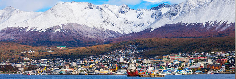
Ushuaia is the capital of Tierra del Fuego, Antártida e Islas del Atlántico Sur Province, Argentina. With a population of nearly 80,000 and a location below the 54th parallel south latitude, Ushuaia claims the title of world's southernmost city.
Ushuaia is located in a wide bay on the southern coast of Isla Grande de Tierra del Fuego, bounded on the north by the Martial mountain range and on the south by the Beagle Channel. It is the only municipality in the Department of Ushuaia, which has an area of 9,390 km2 (3,625 sq mi). It was founded on 12 October 1884, by Augusto Lasserre and is located on the shores of the Beagle Channel surrounded by the mountain range of the Martial Glacier, in the Bay of Ushuaia. Besides being an administrative center, it is a light industrial port and tourist hub. Ushuaia is located roughly 1,100 kilometres (680 mi) from the Antarctic Peninsula and is one of five internationally recognized Antarctic gateway cities.
The Selk’nam Indians, also called the Ona, first arrived in Tierra del Fuego about 10,000 years ago. The southern group of people indigenous to the area, the Yaghan (also known as Yámana), who occupied what is now Ushuaia, lived in continual conflict with the northern inhabitants of the island.
For much of the latter half of the 19th century, the eastern portion of Tierra del Fuego was populated by a substantial majority of nationals who were not Argentine citizens,[clarification needed] including a number of British subjects. Ushuaia was founded informally by British missionaries, following previous British surveys, long before Argentine nationals or government representatives arrived there on a permanent basis.
Ushuaia is located on Ushuaia Bay at 6 meters above sea level, surrounded to the west, north, and east by the Andes Fueguinos. It is the only city accessed from the rest of the country by crossing part of the Andes mountain range that runs along the southern edge of Tierra del Fuego.
Ushuaia has long been described as the southernmost city in the world. While there are settlements farther south, the only one of any notable size is Puerto Williams, a Chilean settlement of some 2,000 residents. As a center of population, commerce, and culture, and as a town of significant size and importance,[26] Ushuaia however clearly qualifies as a city.
Ushuaia features a significantly ocean-moderated mild tundra climate; bordering on a subpolar oceanic climate, with cool, but not cold, conditions throughout the year (average temperature remains above 0 °C and below 10 °C year round). Vegetation around the city thus does not resemble typical tundra but is instead heavily forested. Temperatures at the Ushuaia – Malvinas Argentinas International Airport average 1.3 °C (34.3 °F) in the coolest month (July), and 9.7 °C (49.5 °F) in the warmest month (January).
The southwestern winds make the outer islands wetter, reaching 1,400 mm (55 in) at Isla de los Estados (Staten Island). Because temperatures are cool throughout the year, there is little evaporation. Snow is common in winter and regularly occurs throughout the year. Ushuaia occasionally experiences snow in summer (from November to March). Due to its high southern latitude, the city's climate is influenced by Antarctica, and the duration of daylight varies significantly, from more than 17 hours in summer to just over 7 hours in winter.
| |
Cruise Port of Ushuaia What's in Port -- Ushuaia Tierra del Fuego
| |
Links City Map of Ushuaia Useful Information for Travelers 15 Facts about Ushuaia You Should Know Before Traveling City of Ushuaia, End of the World, Beginning of Everything Wiki Voyage: Ushuaia Beagle Channel Beagle Channel/Glacier Alley Map Beagle Channel and the Strait of Magellan
| |
Tour Information Get Your Guide - Ushuaia Venture Ashore Tours - Ushuaia Viator - Port of Ushuaia Tours Hiking Tours
| |
Further Afield Tierra del Fuego National Park -- 7.5 miles west of Ushuaia Riding the Railway to the End of the World -- End of the World Train
| |
| |
| |
|