|
Our Ship - MARINA
|
Ports
|
Santiago de Chile
|
Puerto Montt, Chile
|
Puerto Chacabuco, Chile
|
Laguna San Rafael, Chile
|
Chilean Fjords
|
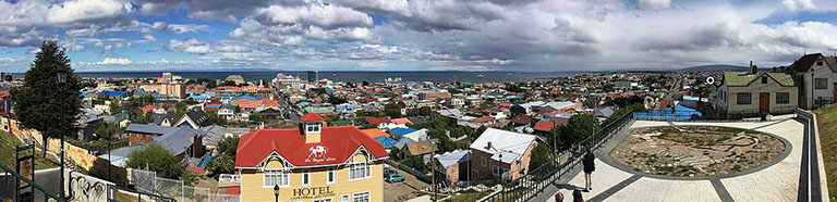
Punta Arenas, Chile
|
Ushuaia, Argentina
|
Drake Passage
|
Antarctica
|
Port Stanley, Falkland Islands
|
Puerto Madryn, Argentina
|
Punta Del Este, Uruguay
|
Montevideo, Uruguay
|
Buenos Aires, Argentina
|
Points of Interest
|
Iguazu Falls
|
Resources
|
Books
|
|
|
|
|
|
|
Punta Arenas, historically known as Sandy Point in English, is the capital city of Chile's southernmost region, Magallanes and Antarctica Chilena. The city is the largest south of the 46th parallel south and the most populous southernmost city in Chile and the Americas. Due to its location, it is also the coldest coastal city with more than 100,000 inhabitants in Latin America. Punta Arenas is one of the world's most southerly ports and serves as an Antarctic gateway city.
Since 1977, Punta Arenas has been one of only two free ports in Chile. Located on the Brunswick Peninsula north of the Strait of Magellan, Punta Arenas was originally established by the Chilean government in 1848 as a small penal colony to assert sovereignty over the Strait. During the remainder of the 1800s, Punta Arenas grew in size and importance due to the increasing maritime traffic and trade traveling to the west coasts of South and North America. This city's growth was also due to waves of European immigrants, mainly from Croatia and Russia, attracted by a gold rush and sheep farming boom in the 1880s and early 1900s.
Since its founding, Chile has used Punta Arenas as a base to defend its sovereignty claims in the southernmost part of South America. This led to the Strait of Magellan being recognized as Chilean territory in the Boundary treaty of 1881 between Chile and Argentina. Punta Arenas' geopolitical importance has remained high in the 20th and 21st centuries due to its logistic significance in accessing the Antarctic Peninsula.
Since 2017, the city and its region have been on their own time zone, using summer time throughout the year (UTC−3).
Located on the Brunswick Peninsula, Punta Arenas is among the largest cities in Patagonia. In 2012, it had a population of 127,454.[7] It is roughly 1,419 km (882 mi) from the coast of Antarctica and 635 km (395 mi) from Ushuaia, the capital of the Argentine province of Tierra Del Fuego.
The Magallanes region is considered part of Chilean Patagonia. Magallanes is Spanish for Magellan, and was named after Ferdinand Magellan, the Portuguese explorer sailing for Spain. While circumnavigating the earth for Spain, he passed close to the present site of Punta Arenas in 1520. Early English navigational documents referred to this site as "Sandy Point."
The city proper is located on the northeastern shore of Brunswick Peninsula. Except for the eastern shore, containing the settlements of Guairabo, Rio Amarillo and Punta San Juan, the peninsula is largely uninhabited. The municipality of Punta Arenas includes all of Brunswick Peninsula, as well as all islands west of the Isla Grande de Tierra del Fuego and north of Cockburn and Magdalena channels.
Due to its far southern latitude, Punta Arenas has a subpolar oceanic climate. The seasonal temperature in Punta Arenas is greatly moderated by its proximity to the ocean, with average lows in July near −1 °C (30 °F) and highs in January of 14 °C (57 °F). It is known for stable constant temperatures, which vary only slightly with the seasons. Rainfall is highest in April and May, and the snowy season runs all through the Chilean winter (June until September). As in most of Patagonia, average annual precipitation is quite low, only 380 mm (15 in) because of a rain shadow created by the Andes.
In the mid-19th century, Chile used Punta Arenas as a penal colony and a disciplinary posting for military personnel with "problematic" behaviour. It also settled immigrants there. In 1867, President José Joaquín Pérez issued a decree offering land grants in an effort to get Chileans or foreigners to settle around Punta Arenas. The first British immigrants arrived in 1867, and their number increased as sheep farming grew in the Chilean Magallanes. The greatest immigration continued to be by the British until 1906, when Croatians surpassed them in numbers. Between about 1890 and 1940, the Magallanes region became an important sheep-raising region.
The Punta Arenas harbour, although exposed to storms, was considered one of the most important in Chile before the construction of the Panama Canal. It was used as a coaling station by the steamships transiting between the Atlantic and Pacific oceans. Today it is mostly used by tourism cruises and scientific expeditions.
| |
Port Guide What's in Port Punta Arenas Cruise Port Cruise Port Guide
| |
Links Punta Arenas - city map and list of important sites, restaurants and markets 14 Great Things to Do in Punta Arenas, Chile The Top 10 Things to See and Do in Punta Arenas, Chile Things to Do in Punta Arenas Punta Arenas - Chile's Oil-Rich Gateway to the Antarctic Visit Punta Arenas
| |
Tours Get Your Guide - Punta Arenas Chile Dream Tours - Punta Arenas Calaio Viajes y Turismo
| |
| |
| |
|