|
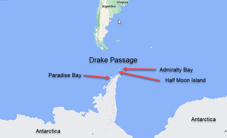
Antarctica Cruising by Half Moon Islands, Antarctica Day 11 - Saturday, February 24, 2024 Cruising by Paradise Bay, Antarctica Day 12 - Sunday, February 25, 2024 Admiralty Bay, Antarctica (South Shetland Islands) Day 13 - Monday, February 26, 2024 |
|
Our Ship - MARINA
|
Ports
|
Santiago de Chile
|
Puerto Montt, Chile
|
Puerto Chacabuco, Chile
|
Laguna San Rafael, Chile
|
Chilean Fjords
|
Punta Arenas, Chile
|
Ushuaia, Argentina
|
Drake Passage
|
Antarctica
|
Port Stanley, Falkland Islands
|
Puerto Madryn, Argentina
|
Punta Del Este, Uruguay
|
Montevideo, Uruguay
|
Buenos Aires, Argentina
|
Points of Interest
|
Iguazu Falls
|
Resources
|
Books
|
|
|
|
|
|
|
In cruising in Antarctica, it is both difficult to define some of the places we are scheduled to go to, and it is my understanding that if the weather is not good at one spot, the Captain may decide to go elsewhere in the area to get some good viewing.
| |
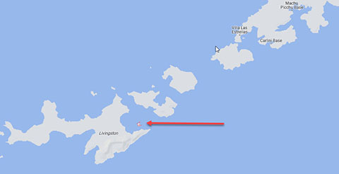
Half Moon Islands
| |
| |
The Itinerary says that we are cruising by Half Moon Islands, Antarctica. The only place I could identify with the name Half Moon is a small island in the South Shetland Islands in between Livingston and Greenwich Islands. This small island is shown in the image, but I am unsure that that is where we are going. Half Moon Island is a minor Antarctic island, lying in McFarlane Strait 1.35 km (0.84 mi) north of Burgas Peninsula, Livingston Island in the South Shetland Islands of the Antarctic Peninsula region. Its surface area is 171 hectares (420 acres). The Argentine Cámara Base is located on the island. It is only accessible by sea and by helicopter; there is no airport of any kind. The island is a series of gravel bars (tombolos) connecting volcanic bedrock islands. The volcanism is not recent and may be millions of years old. The crescent shaped island may be the result of an eroded caldera.
| |
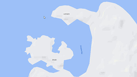
Paradise Bay
| |
| |
Paradise Bay, or Paradise Harbor, seems to be readily identifiable, east of the southern end of Anvers Island. Paradise Harbour, also known as Paradise Bay, is a wide embayment behind Lemaire and Bryde Islands in Antarctica, indenting the west coast of Graham Land between Duthiers and Leniz Points. The name was first applied by whalers operating in the vicinity and was in use by 1920. Argentina's Almirante Brown Antarctic Base stands on the coast of the bay, as does Chile's González Videla Antarctic Base. In 1950, a shelter was erected near the Chilean Base to honour Gabriel Gonzalez Videla, the first head of state to visit the Antarctic. The shelter constitutes a representative example of pre-IGY activity in Antarctica. It has been designated a Historic Site or Monument (HSM 30), following a proposal by Chile to the Antarctic Treaty Consultative Meeting
| |
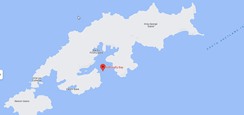
Admiralty Bay, South Shetland Island, Antarctica
| |
| |
Admiralty Bay is the largest bay on the southern side of King George Island in the South Shetland Islands. Admiralty Bay is an irregular bay, 8 km (5 mi) wide at its entrance between Demay Point and Martins Head, indenting the southern coast of King George Island for 16 km (10 mi), in the South Shetland Islands of Antarctica. The name appears on a map of 1822 by Captain George Powell, a British sailor, and is now established in international usage. The Henryk Arctowski Polish Antarctic Station is situated on the bay, as is the Comandante Ferraz Brazilian Antarctic Base. It has been designated an Antarctic Specially Managed Area. The bay has three fjords: Martel, Mackellar, and Ezcurra. A mariner's guide to the region pronounced the bay to have the best anchorage of any in the South Shetlands, "being well-sheltered all around and having moderate depths over a bottom of good, stiff clay.
| |
| |
|
|
|
|
|
|